By installing After Effects software, you can edit this project as you wish and in any language.
16.7 MB
ZIP
AE-CC
Original
Khalaj.Net
Works out of the box—no extra plugins needed.
Full HD for modern screens and platforms.
Step-by-step guide to help customize easily.
text, media, timing, and layout with full control.
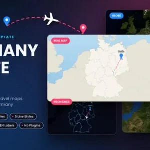
This project provides an interactive animated map of Germany, covering all 16 states. Users can select starting and ending locations, generating smooth, dynamic route animations.
The map offers multiple visual styles, including classic topographic, neon line, satellite imagery, and a 3D globe perspective, allowing for flexible visual adaptation to different project needs. Routes are displayed with a variety of line styles, solid, dashed, dotted, and neon, and travel icons such as planes, boats, and cars can be added along the path.
An intelligent camera system automatically adjusts zoom, pull-back, and landing movements based on the length and direction of each route, ensuring clear and engaging visual storytelling. This asset is ideal for travel documentaries, educational geography presentations, and news segments that require clear, location-based data visualization. The map can be easily integrated into video projects to highlight journeys between German cities or states. Travel icons and map styles can be selected to match your project’s identity.


Send your photos and instructions for this slideshow.